

Get faster, more accurate data capture for your field operations — without the complexity of office-centric tools.
Ignite field productivity with the Fulcrum platform
If your field tools create more frustration than efficiency, it’s time for Fulcrum. With AI-powered automation, location intelligence, and innovations like Audio FastFill, your teams will work faster, capture more accurate data, and get more done — without the hassle.
See the difference a field-first platform makes

Eliminate the complexity and confusion of multiple bolt-on apps by standardizing on one field data collection platform.

Empower teams to adapt quickly by customizing their own field operation apps — with IT and GIS team oversight as needed.

Get better data faster by integrating AI, FieldTech, GIS, and office-based systems into field workflows.
From bolt-on to built-in: Why a unified platform is the future of field process management
Learn how unified field software can help your organization simplify processes, save time, and achieve more.

“For CIOs and digital transformation leaders looking to streamline field operations, the category of location-enabled Field Process and data Collection Platforms offers a transformative alternative to outdated methods. These platforms are a critical tool for driving efficiency, flexibility, and ensuring data accuracy across field operations.”
![]() Lynne Schneider, Research Director
Lynne Schneider, Research Director
IDC
Bring innovation to the front lines
You’ll be amazed at the number of ways Fulcrum helps your teams streamline field data collection processes, radically boost productivity, and enable even tech-resistant teams to capture better field data.

Bring innovation to the front lines
You’ll be amazed at the number of ways Fulcrum helps your teams streamline field data collection processes, radically boost productivity, and enable even tech-resistant teams to capture better field data.

Inspections
Ensure asset integrity with AI-assisted, automatically geotagged inspections that are easy for anyone to use.

Maintenance SOPs
Make it fast and easy for field workers to prove their compliance with repair and maintenance processes.
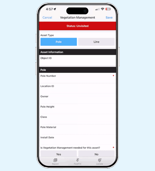
Field Processes
Streamline workflows for smart tech installs, vegetation management, remediation tasks, and more.

Safety
Reduce field risks with flexible, easy-to-use tools for tracking everything from lockout/tagout and tailgate talks to confined space permits.
Transform your field operations
When struggling with inefficient tools in the field, Fulcrum provides a platform that boosts productivity and streamlines operations for your field teams.


Standardization

Customization

Integration
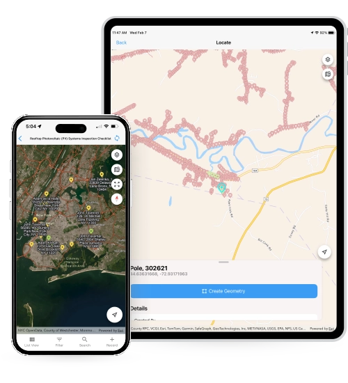
Geospatial capabilities
Our best-in-class geospatial capabilities make field operations a breeze. Here’s just a glimpse of what we offer:
- Customizable basemaps with data, layers, and geometries display, even when offline
- Direct viewing of Feature Service Layers with secure in-app authentication to ArcGIS
- Simple controls for location capture, including advanced geospatial geometries
- Geostamped audit trails to track and verify record locations
AI built for the field, ready for work
Audio FastFill uses AI to turn spoken observations into structured data — hands-free and hassle-free.
- Faster — Complete field tasks 20% faster by reducing manual data entry
- Smarter — Handles text, numbers, checkboxes, and conditional entry with no extra effort
- Built-in — Use on existing forms with no setup or training
- Designed for fieldwork — Collect data hands-free, even when wearing gloves or on the move
You can also automate workflows in Fulcrum — even in offline environments — using custom AI models.
Enterprise features
Fulcrum supports organizations of all sizes with enterprise-class features to meet stringent requirements and boost productivity, including:
- Efficient project organization
- Groups, roles, and projects management
- SCIM and SSO integration
- SOC 2 Type 2 compliance

A day in the life of your field data
Your field data is always in motion, flowing seamlessly from the field to your office systems and back again. The Fulcrum field process and data collection platform is your system of record, bringing it all together.
Transforming field operations with Fulcrum
Fulcrum revolutionized Brown and Caldwell’s water utility projects, slashing data management hours by 30% and helping it ditch paper forms for good. With cutting-edge field data collection technology, its operations became smoother, faster, and more precise, turning complex tasks into streamlined processes.
Brown and Caldwell

Boost inspection speed by 600%
Santa Barbara County Fire Department improved the efficiency of its wildfire prevention program by adopting Fulcrum, enabling the agency to perform over six times more daily inspections. Fulcrum’s real-time data and customization enhanced visibility and resource allocation, allowing the SBCFD to increase its defensible space inspection completion rate from less than 50% to over 90%.
Santa Barbara County Fire Department

Integrating FieldTech tools
Transitioning to Fulcrum significantly shifted how SCE managed its field operations and data collection processes. From simplifying app creation to integrating advanced FieldTech tools, Fulcrum has enabled SCE to enhance its operational efficiency and adaptability, reshaping the utility’s approach to project management, regulatory compliance, and emergency response.
Southern California Edison (SCE)
